Map and atlas collection, 1795-1980
1894 Map of Longmeadow
Scope and Content Note
The Longmeadow maps and atlases collection documents the growth and development of Longmeadow from the early 19th century to the late 20th. Highlights in the collection include an 1831 map of Longmeadow, an 1835 map of Springfield, MA, an 1844 topographical map of Massachusetts, and an 1855 map of Hampden County, Massachusetts. In addition to plans, maps, and atlases for Longmeadow and East Longmeadow, there are plans for Colony Hills, Glen Arden, and Laurel Manor, early 20th century developments in the area. Bound atlases dating from 1894 to 1933 for Longmeadow and the surrounding area are also included. A more detailed item-level listing follows.
Five of the maps of Longmeadow have been photographed and are available as prints suitable for framing: http://www.longmeadowhistoricalsociety.com/category-s/102.htm.
Box and Folder Listing: Maps
| Title | Date | Description | Notes | Location |
|---|---|---|---|---|
| Longmeadow No. 30 County Hampshire | 1795 | 4 different reproductions of the manuscript map | Original in the Mass archives, Maps & Plans #1134 | Folder 1 |
| Plan of Longmeadow | 1831 | Surveyed in April 1831. Reproduction | Original in the Mass archives, Maps & Plans #1970 | Folder 1 |
| A Plan of Longmeadow from the survey of 1831 | 1831 | Engraved by J. H. Goldthwait. Original linen-backed wall map rolled on dowels. 2 copies | One copy in better condition than the other. Facsimiles and photocopies available | Box on B-1 |
| Map of Hampden County by Henry Francis Walling | 1857 | Published by H. A. Haley. This is a reproduction of the section of the map depicting Longmeadow | Photocopy available | Folder 1 |
| Atlas of Hampden County, Mass. by F. W. Beers, page 38 | 1870 | 2 different reproductions of the page depicting the towns of Longmeadow and East Longmeadow and listing the subscribers’ business reference | LHS does not appear to have the original Beers atlas. Facsimiles and photocopies available | Folder 1 |
| Atlas of Hampden County, Mass. by F. W. Beers, page 37 | 1870 | 2 different reproductions of the half of the page depicting Longmeadow and East Longmeadow in their entirety | LHS does not appear to have the original Beers atlas. Photocopies available | Folder 1 |
| Map of Longmeadow, Hampden County Mass | 1892 | Original, one reproduction, and a (possibly later?) printing with additional information around the borders. Depicts the proposed division line between Longmeadow and East Longmeadow | Photocopies of a detail available | Folder 1 |
| New Topographical Atlas of the County of Hampden, Mass by L. J Richards and Co., page 93 | 1894 | 2 different reproductions of the page depicting East Longmeadow, with an inset of the Village of East Longmeadow | LHS has the original Richards atlas. Photocopies available | Folder 1 |
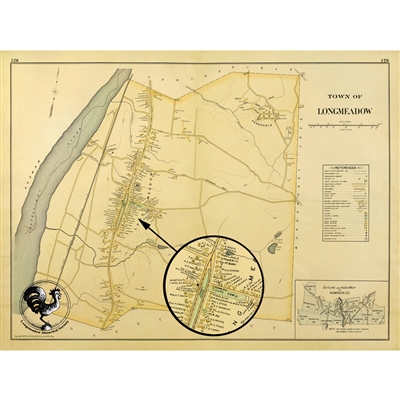
| New Topographical Atlas of the County of Hampden, Mass by L. J Richards and Co., pages 128-129 | 1894 | Depicts the town of Longmeadow. Original and 3 different reproductions, one of which is enlarged and vertical, focusing on Main Street (now Longmeadow Street) | LHS has the original Richards atlas. Facsimiles and photocopies available | Folder 1 |
| Plan of Lots near State Line, Longmeadow Mass, owned by Emily W. Smith | 1898 | Drawn by George N. Merrill. 2 reproductions | Location of original unknown. Photocopies available | Folder 1 |
| Atlas of the City of Springfield and Town of Longmeadow, Mass by L. J Richards and Co., plate 25 | 1910 | Depicts the town of Longmeadow with a topological map of Forest Park which includes a list of Board of Park commissioners and a list of owners. Original | LHS has the original Richards atlas. Photocopies available | Folder 2 |
| Atlas of the City of Springfield and Town of Longmeadow, Mass by L. J Richards and Co., plate 26 | 1910 | Depicts the town of Longmeadow. Original and one reproduction. | LHS has the original Richards atlas. Facsimiles available. | Folder 2 |
| Richards Standard Atlas of Hampden County, Mass by L. J Richards Map Company, plate 18 | 1912 | Depicts the town of Longmeadow. 3 originals. | LHS has the original Richards atlas (loose plates). Photocopies available | Folder 2 |
| Richards Standard Atlas of Hampden County, Mass by L. J Richards Map Company, plate 17 | 1912 | Depicts the town of East Longmeadow. Original | LHS has the original Richards atlas (loose plates). | Folder 2 |
| Map of Street in Longmeadow | 1917 | Blueprint of map showing streets and showing some structures including church, school house, and garage. | Folder 2 | |
| Richards Standard Atlas of the City of Springfield and the Town of Longmeadow, Mass by Richards Map Company, plate 21 | 1920 | Depicts the town of Longmeadow with a topological map of Forest Park which includes a list of Board of Park commissioners and a list of owners. Includes sub plan no. 4: Greenwood Manor and Loleta Park and sub plan no. 6: Brookdale Manor. Original and photograph which includes Longmeadow section only. | LHS has the original Richards atlas. | Folder 2 |
| Richards Standard Atlas of the City of Springfield and the Town of Longmeadow, Mass by Richards Map Company, plate 22 | 1920 | Depicts the town of Longmeadow. Original | LHS has the original Richards atlas. Facsimiles available. | Folder 2 |
| Colony Hills, Springfield, Mass. General Plan for Development of Property | 1921 | Olmsted Brothers, Landscape Architects. Depicts layout of lots with dimensions for proposed development. Reproduction | Original may be at Frederick Law Olmsted National Historic Site. Photocopies available. | Folder 2 |
| Map of Longmeadow, Mass | 1925 | Merrill & Sears, Civil Engineers. Shows new Springfield/Longmeadow boundary and golf club. Reproduction | Original may be at Frederick Law Olmsted National Historic Site | Folder 2 |
| Laurel Manor. Property of Victor Corporation, Longmeadow, Mass. General Plan for Development | 1926 | Olmsted Brothers, Landscape Architects. Depicts layout of lots with dimensions for proposed development. Reproduction. | Original may be at Frederick Law Olmsted National Historic Site. Photocopies available. | Folder 2 |
| Plan of Forest Acres in Longmeadow, Mass. | 1927 | Clifton W. Kibbe, owner. Walker, Walker and Kingsbury, Architects, Landscape Architects and Town Planners. Depicts layout of lots with dimensions for proposed development. Reproduction. | Photocopies available. | Folder 2 |
| Plan showing a part of the T. W. Leete Estate, Longmeadow Mass. | 1927 | Durkee, White & Towne, Engineers. Plan includes acreage of portions of the Leete Estate some of which formed the Glen Arden development. Original blueprint | Note on back reads: “ Land sold to Glen Arden. White & Quinn (?) lots. Part of Leete Estate” | Folder 2 |
| Colony Hills, Springfield, Mass. General Plan for Development of Property | 1928 | Depicts layout of lots for proposed development. Includes additional lots not found in 1921 version. Reproduction | Original may be at Frederick Law Olmsted National Historic Site. | Folder 2 |
| Glen Arden, Longmeadow, Mass. General Plan | 1928 | Olmsted Brothers, Landscape Architects. Depicts layout of lots with dimensions for proposed development. Reproduction. | Original may be at Frederick Law Olmsted National Historic Site. | Folder 2 |
| Plan for proposed development along the Longmeadow and East Longmeadow line. | 1928 | J.D. Colton, Engineer. Plan locates a proposed golf course and airport. Original blueprint. | Folder 2 | |
| Plan of proposed park, Longmeadow, Mass. | 1929 | Merrill & Sears, Civil Engineers. Plan locates proposed park located to the east of the Glen Arden development. Original blueprint. |
Box on F1-G1 | |
| Longmeadow Park Commission, Preliminary Plan for Park | 1934 | Olmsted Brothers, Landscape Architects. Depicts layout of proposed park between Farmington Avenue and Westmoreland Avenue | Box on F1-G1 | |
| Map of Longmeadow Mass. Showing Division of Precincts | 1938 | Printed map showing Precincts A, B, and C. | Signed H.C. Dudley – perhaps his copy | Folder 2 |
| Longmeadow Zoning Map | 1942 | Printed map with key outlining various requirements for specific zones. | Folder 2 | |
| Glen Arden, Longmeadow, Mass. General Plan | 1945 | Olmsted Brothers, Landscape Architects. Depicts layout of lots with dimensions for proposed development. Includes additional lots not included in 1928 version. Reproduction. | Original may be at Frederick Law Olmsted National Historic Site. Photocopies available. | Folder 2 |
| Map of Longmeadow, Massachusetts | 1949 | Printed map showing major street and roads and locations for existing schools. | Folder 2 | |
| Map of Longmeadow, Massachusetts | 1960-61 | 1 photograph of map and 1 small printed version with “Stearns and Wescott, Realtors” added. | Smaller version signed Mrs. Alfred Wood | Folder 2 |
| Plan of Longmeadow | 1965 | Robert T. Bitters. Plan showing original land grants from 1645 in the “Meddowe” along the Connecticut River, original land grants from 1703 along the “Street,” and land as owned when the New Haven, Hartford and Springfield Railroad was built. 3 reproductions | Photocopies available. | Folder 2 |
| Map of Longmeadow, Massachusetts | 1968 | Printed map. Includes additional streets not found on 1960-1 version. Includes a street index on the reverse. Original | Folder 2 | |
| New Map of Longmeadow by the Price and Lee Company, | 1969 | Includes maps of East Longmeadow, Ludlow, West Springfield, Wilbraham, Hampden, and Agawam. Includes a street indexes. Original | Folder 2 | |
| New Map of Longmeadow by the Price and Lee Company, | 1971 | Includes maps of East Longmeadow, Ludlow, West Springfield, Wilbraham, Hampden, and Agawam. Includes a street indexes. Original | Folder 2 | |
| Map of the Town of Longmeadow | 1972 | Depicts the town of Longmeadow. Original | Folder 2 | |
| Plan Showing Longmeadow Historic District | 1973 | Longmeadow Engineering Department. Plan shows boundaries of the Historic District and properties along Longmeadow Street. 2 reproductions. | Photocopies available. | Folder 2 |
| Aerial Photograph of Longmeadow | 1980 | Aerial photograph of the Longmeadow area, dated 3.19.1980 | Folder 2 | |
| Plan showing Leete Estate in Longmeadow, Massachusetts | undated | Depicts the various properties that made up the Leete Estate. Original blueprint. | Note on back reads: “Old Map Leete Estate before selling any.” |
Box on F1 – G1 |
| Map of Springfield | Circa 1770 | Photograph of map depicting Springfield from 1770-1800. Notes various events occuring during the stated time period and names associated with structures depicted. | Folder 3 | |
| Plan Map of Springfield by George Colton | 1835 | Depicts Springfield area and includes names of landowners, streets and a plan of Franklin Square. Original linen-backed wall map rolled on dowels |
Box on D1-E1 | |
| Topological Map of Massachusetts … Made by order of the Legislature. Published by Charles Hickling | 1844 | Includes tables of demographic information, and inset: “Geological map of Massachusetts, made by order of the legislature, by Edward Hitchcock, 1844.” Original linen-backed wall map rolled on dowels |
Box on D1-E1 | |
| Map of Hampden Co., Massachusetts Based on Surveys under Direction of Henry F. Walling. H. A. Haley, publisher | 1855 | Includes ancillary maps of Springfield, Westfield, Chicopee, Holyoke, Brimfield and other Hampden County townships. 2 original linen-backed wall maps rolled on dowels |
Box on B1-C1 | |
| The Village of Springfield from 1775 to about 1800. | Circa 1870 | Includes a directory of notable homes and other structures. Reverse has illustration of the Pynchon House and a view showing the the Milton Bradley Company factory. | Folder 3 | |
| Atlas of Hampden Co., Massachusetts, from actual surveys by and under the direction of F.W. Beers, assisted by Geo. P. Sanford and others. Plate 9 | 1870 | Plan of Hampden Co. Massachusetts. Original | Folder 3 | |
| Map of the City of Springfield, Mass. | 1884 | Includes a directory of Public buildings. Published by the Springfield Printing Co. Engraved and Printed by Milton Bradley Co. | Folder 3 | |
| Map of the City of Springfield, Mass. and Vicinity. | 1903-1904 | Published by the Price & Lee Co. for the city directory. Litho. by Milton Bradley Co. | Folder 3 | |
| New Topological Map of Forest Park, Springfield, Mass by L.J. Richards | 1909 | Permit to Use An Automobile in Forest Park. Based on Surveys by Chas. M. Slocum. Original | Folder 3 | |
| New Map of the City of Springfield by the Price and Lee Company, | 1912 | Depicts the city of Springfield. Published for the City Directory. Includes a street index. Original | Folder 3 | |
| Springfield Street Railway, Map 524. Transit Map Series by Donald E. Shaw | 1946 | Depicts trackage operated by the Springfield Street Railway in Southwestern Massachusetts. Includes a small inset map for Suffield, Connecticut. Reproduction in 2 parts. | Folder 3 | |
| U.S. Geologic Survey Quadrangle for Springfield South, MA | 1944 | Geologic Survey map depicting Springfield, East Longmeadow, Longmeadow and a portion of Connecticut. 2 photocopies. | Additional photocopies available. | Folder 3 |
| Map of the City of Springfield by the Price and Lee Company, | 1957 | Depicts the city of Springfield. Includes a New Map of Longmeadow, a New Map of Chicopee, and a New Map of West Springfield on the verso. Includes a street index. Original | Folder 3 | |
| Map of the City of Springfield by the Price and Lee Company, | 1967 | Depicts the city of Springfield. Includes a street index. Original | Folder 3 | |
| U.S. Geologic Survey Quadrangle for Springfield South, MA | 1970 | Geologic Survey map depicting Springfield, East Longmeadow, Longmeadow and a portion of Connecticut. Original | Folder 3 | |
| Enfield Historical Society maps of Enfield, Hazardville, Scitico, Thompsonville, and the Enfield Shaker village. | 1975 | Reprint images from Atlas of Hartford City/County by Baker and Tilden, 1869, with additional historical text and photographs. 4 reproductions | Folder 3 | |
| Surficial geologic map of the Hampden Quadrangle, Massachusetts and Connec | 1982 | Geologic Survey map includes Springfield, East Longmeadow, Longmeadow and a portion of Connecticut. | Folder 3 | |
| Long Trail Forest Park, Springfield, Mass. | undated | Plan of Forest Park with legend locating many park features including log seats, rustic shelters, trees, and lookouts. Original | Photocopies available. | Folder 3 |
| Map of Deerfield, Mass. | undated | Facsimile of a map in “Atlas of Franklin County, Massachusetts,” F.W. Beers, 1871. Depicts Deerfield township, and includes Deerfield Centre P.O., Mill Village, Wapping Greenfield P.O. and South Deerfield, P.O. | Folder 3 | |
| Map of Old Deerfield, Incorporated 1676 | Circa 1970s | Depicts early Deerfield and includes the Stockade, the Liberty Pole, Deerfield Academy, Old Stebbins House and other historic houses and structures. | Folder 3 | |
| U.S. Geologic Survey Quadrangle for Springfield South, MA | undated | Detail of Geologic Survey map focusing on Longmeadow. 2 color photocopies | Additional photocopies available. | Folder 3 |
| Bowles’s new pocket map of the most inhabited part of New England; comprehending the provinces of Massachusets Bay and New Hampshire; with the colonies of Connecticut & Rhode Island; divided into their counties, townships, &c. together with an accurate plan of the town, harbour and environs of Boston | undated | Facsimile of a map depicting New England in 1780. | Folder 3 | |
| The Cerographic Bible Atlas by Sidney E. Morse, A.M. New York |
1844 | “Quarterly Supplement to the New York Observer”. Maps included: General Map of the Countries Mentioned in the Bible; Map of the Journeyings of the Israelites in the Desert chiefly from the map of Robinson and Smith; Map of Palestine from the Latest Authorities chiefly from the map of Robinson and Smith; Plan of Jerusalem from the map of Robinson and Smith & Environs of Jerusalem from the map of Robinson and Smith; Map of the Travels of the Apostles chiefly from the map of Dr. Augs. Neander. Original | Folder 4 | |
| The World At One View. Entered … 1847, by H. Phelps … New York. | 1847 | Published by Ensign and Thayer. Includes heights of mountains, lengths of rivers, female costumes, and population of the world. Original. | Folder 4 | |
| Monk’s New American Map Exhibiting the larger portion of North America, Embracing the United States and Territories, Mexico, and Central America … Published by Jacob Monk | 1856 | Includes a Table of Distances. Original linen-backed wall map rolled on dowels | Box on D1-E1 | |
| Map of the Eastern Portion of the Mediterranean Sea and a Portion of the Black Sea. | Circa 1871 | Map in German. Written on the back “Charles R. Bliss. Steamer “Venus,” Sept. 11 / 71 Adriatic Sea” Original | Folder 4 |
Box and Folder Listing: Atlases
| Title | Date | Description | Location |
|---|---|---|---|
| Colton’s General Atlas, Containing One Hundred and Seventy Steel Plate Maps and Plans, on One Hundred Imperial Folio Sheets. New York: J. H. Colton & Co. | 1857 | Includes geographical, statistical, and historical descriptions by Richard S. Fisher, M.D. Original | Shelf 2 |
| New Topographical Atlas of the County of Hampden, Mass by L. J Richards and Co. | 1894 | Original. 2 copies | Shelf 1 |
| Atlas of the City of Springfield and Town of Longmeadow, Mass by L. J Richards and Co. | 1910 | Original | Shelf 1 |
| Richards Standard Atlas of Hampden County, Mass by L. J Richards Map Company | 1912 | Loose sheets. Includes Longmeadow, plate 18 | Folder 5 |
| Atlas of the boundaries of the cities of Chicopee and Springfield and towns of Brimfield, East Longmeadow, Hampden, Holland, Longmeadow, Ludlow, Monson, Palmer, Wales, Wilbraham, Hampden County : Belchertown, Granby, South Hadley, Ware, Hampshire County : Brookfield, North Brookfield, Southbridge, Sturbridge, Warren, West Brookfield, Worcester County | 1912 | By the Board of Harbor and Land Commissioners of Massachusetts. Includes descriptions of lines as they existed at the time of publication, and geographical positions in latitude and longitude. Original. | Shelf 2 |
| Map of Longmeadow, Mass. | 1917 | Merrill & Sears, Civil Engineers. | Shelf 2 |
| Richards Standard Atlas of the City of Springfield and the Town of Longmeadow, Mass by Richards Map Company | 1920 | 2 copies | Folder 6 Shelf 1 |
| Insurance Map of Longmeadow by Sanborn Map Company. | 1931 | Depicts commercial and residential sections of Longmeadow showing size, shape and construction of buildings and the materials used in their construction. Updated to 1947. Original (“Loaned to H.H. Landon, Agent”) | Shelf 2 |
| Insurance Map of Longmeadow by Sanborn Map Company. | 1931 | Depicts commercial and residential sections of Longmeadow showing size, shape and construction of buildings and the materials used in their construction. Updated to 1956. Includes a typed street index and a printed copy of proposed revised by-law for the town of Longmeadow, 1952. Original | Shelf 2 |
| Atlas of Longmeadow | 1933 | Merrill & Sears, Civil Engineers. Includes an Index of Streets. 13 blueprint plates of Longmeadow showing buildings, streets, and properties. Includes some handwritten additions. Original | Shelf 2 |
Subjects
- Housing development--Massachusetts
- Land subdivision--Massachusetts--Longmeadow
- Land subdivision--Massachusetts--Springfield
- Longmeadow (Mass.)--History
Contributors
- Olmsted Brothers
Types of material
- Atlases
- Maps